Citation
Carly H. Hansen and Paul G. Matson. 2023. Hydropower Infrastructure – Lakes, Reservoirs, and RIvers (HILARRI), Version 2. HydroSource. Oak Ridge National Laboratory, Oak Ridge, Tennessee, USA. DOI: 10.21951/HILARRI/1960141
Overview
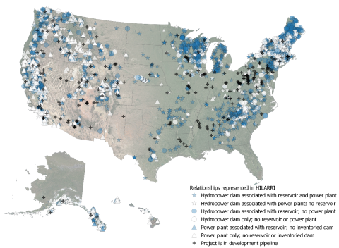
HILARRI is a database of links between major datasets of operational hydropower dams and powerplants, and inland water bodies. These connections are critical for conducting large-scale analysis of hydropower infrastructure and their associated natural and engineered water systems. Features include:
• Dams from the National Inventory of Dams (2021) and the Global Reservoir and Dam Database (GRanD v1.3)
• Hydropower plants from the Existing Hydropower Assets dataset (EHA 2022)
These hydropower infrastructure features are linked to several major datasets that provide hydrologic and hydraulic information relevant for analysis of hydropower systems that includes the integral water resources as seen in Figure 1 (Datasets highlighted in blue were created outside of ORNL, those highlighted in yellow can be found on HydroSource). That information comes from:
• Products from the National Hydrography Dataset (NHD)
- NHDPlusV2 Medium Resolution river network flowlines,
- NHD waterbodies (limited to lakes and reservoirs),
- NHD Watershed Boundary Dataset (HUC12-level for the Conterminous United States (CONUS))
- NHD High Resolution waterbodies
• HydroLAKES water bodies (lakes and reservoirs)
• LAGOS-US lakes
Unique identifiers are used to facilitate joining to the original full datasets. For example, characteristics of NHD flowlines (such as estimated average flow rate) can be joined from the NHDPlusV2 dataset to infrastructure listed in HILARRI based on the ID field, “COMID”, that is common to both datasets. HILARRI only includes basic information about identifiers, location, and data quality or usage notes.
The HILARRI dataset also incorporates information from additional datasets to facilitate more effective and accurate analysis of hydropower infrastructure and their associated waterbodies. For example, dams were checked against the most recent American Rivers Dam Removal Database to identify and flag facilities that may no longer exist. Additionally, dams that are listed multiple times in the NID are identified and flagged to avoid double-counting when analyzing and summarizing information. Other quality flags include certainty of operational hydropower (i.e., if one or more datasets indicates hydropower at a particular location), whether an associated water body is accurate or composed of multiple polygons, or whether there is a known issue with reported characteristics in one of the underlying datasets. These additional data flags are designed to increase confidence in data usage for individual to large-scale analyses.
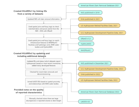
Figure 1: Workflow showing key steps for creating links between datasets in HILARRI.
Science Themes
Related Records
HydroSource Data Explorer
View ToolOverview of Fish Passage Facilities at Hydropower Developments across the Conterminous United States
This dataset contains geo-referenced information on fish passage facility existence, type, and direction at hydropower developments across the conterminous United States (CONUS).
View Dataset