Citation
Paul G. Matson, Bryan B. Bozeman and Christopher R. Derolph. 2025. Overview of Fish Passage Facilities at Hydropower Developments across the Conterminous United States. HydroSource. Oak Ridge National Laboratory, Oak Ridge, Tennessee, USA. DOI: 10.21951/Fish_Passage_Webmap_Dataset_V1/2563190
Overview
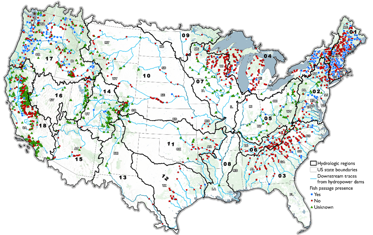
This dataset contains geo-referenced information on fish passage facility existence, type, and direction at hydropower developments across the conterminous United States (CONUS) presented in the ORNL Hydropower Fish Passage Webmap. It was developed through collaborative partnerships with fish passage engineers and biologists at both the US Fish and Wildlife Service (USFWS) and the National Marine Fisheries Service (NMFS), and hydropower experts at the Low Impact Hydropower Institute (LIHI). Information contained within this dataset has been provided by many different sources, including State and Federal resource management agencies, non-governmental organizations, hydropower industry members, and published datasets. This dataset contains one data file in comma-separate (*.csv) format.
Keywords
Science Themes
Related Records
Hydropower Fish Passage Webmap
View ToolHydropower Infrastructure – Lakes, Reservoirs, and RIvers (HILARRI), Version 2
HILARRI is a database of links between major datasets of operational hydropower dams and powerplants, and inland water bodies.
View DatasetExisting Hydropower Assets (EHA) Plant Database, 2024
The Existing Hydropower Assets (EHA) Plant Database is a geospatially comprehensive point-level dataset containing locations and key characteristics of U.S. hydropower plants that are currently operational.
View DatasetNational Hydropower Fish Passage Database
This database contains information on fish passage facility engineering characteristics, targeted fish species, operational schedule, and costs, which is of great value to a diverse range of stakeholders.
View DatasetA census of fish passage facilities at US hydropower developments across the conterminous United States
Matson, P. G., Bozeman, B. B., DeRolph, C. R., Oladosu, G. A., Singh, D., Richie, D., … & Fischer, M. (2025). A census of fish passage facilities at US hydropower developments across the conterminous United States. Journal of Environmental Management, 391, 126623.
View Publication