Citation
Jiyong Lee, Mirko Musa, Soumendra Bhanja, Antonia Chu, Carly H. Hansen, Debjani Singh and John Zhu. 2026. Hydrological Dataset for Reservoir Sedimentation in Texas. HydroSource. Oak Ridge National Laboratory, Oak Ridge, Tennessee, USA.
Overview
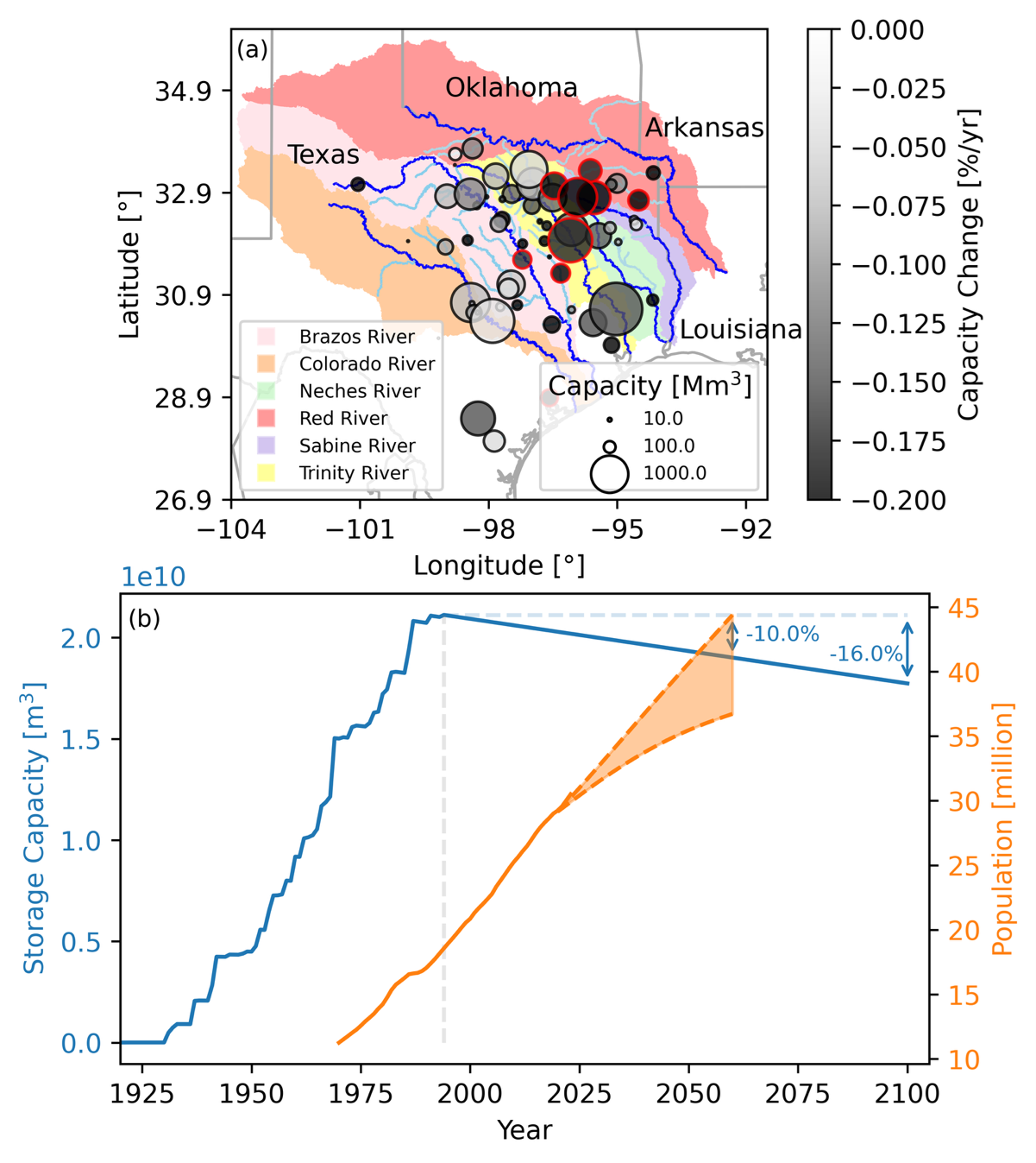
This dataset provides comprehensive hydrological information about reservoir sedimentation in Texas, including observed and remotely sensed sediment concentration, river discharge, watershed boundary, lake geometry, reservoir capacity, land use and land cover (LULC), and population data. In-depth interpretation of the dataset is elaborated in a journal article, entitled “Sedimentation hotspots and nonlinear trapping in Texas reservoirs identified using remote sensing and bathymetric survey records (submitted to Water Resources Research).
Reservoir capacity survey data from Texas Water Development Board (TWDB) were digitized to quantify capacity loss and sedimentation rates. Next, relative changes in sediment flux were computed using remotely sensed sediment concentration data to identify regions with increased flux compared to the past. These regions align with locations of reservoirs that show high sedimentation rates in the repeated bathymetric survey data, i.e., sedimentation hotspots (red edged circles in the figure). In addition, remotely sensed sediment flux data were used to calculate differences between incoming and exiting sediment within reservoirs, which allows to demonstrate nonlinear sediment trapping processes.This hydrological dataset for Texas reservoirs is linked to several major datasets that provide hydrologic and hydraulic information relevant for analysis of reservoir sedimentation. That information comes from:
1) Products from the National Hydrography Dataset (NHD)
- Modeled river discharge: Enhanced Runoff Method (EROM)
- NHD Watershed Boundary Dataset
2) HydroLakes
3) Historical population from United States Census Bureau (USCB)
4) Future projection of population from Texas Demographic Center (TDC)
5) Reservoir capacity data from Texas Water Development Board (TWDB)
6) River discharge and sediment concentration data from U.S. Geological Survey (USGS)
7) National Land Cover Database (NLCD)
8) Remotely sensed sediment concentration data, RiverSed (https://zenodo.org/records/4900563#.ZGJo3XbMKUk)