Citation
2024. CMIP6-based Multi-model Hydroclimate Projection over the Conterminous US, Version 1.1. Oak Ridge National Laboratory, Oak Ridge, Tennessee, USA. DOI: 10.13139/OLCF/2311812
Overview
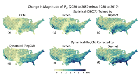
This dataset presents a suite of high-resolution downscaled hydro-climate projections over the conterminous United States (CONUS) based on multiple selected Global Climate Models (GCMs) from the Coupled Models Intercomparison Project phase 6 (CMIP6). The CMIP6 GCMs are downscaled using either statistical (DBCCA) or dynamical (RegCM) downscaling approaches based on two meteorological reference datasets (Daymet and Livneh). Subsequently, the downscaled precipitation, temperature, and wind speed are employed to drive two calibrated hydrologic models (VIC and PRMS), enabling the simulation of projected future hydrologic responses across the CONUS. This dataset is formulated to support the SECURE Water Act Section 9505 Assessment for the US Department of Energy (DOE) Water Power Technologies Office (WPTO). For further details on this dataset, please refer to Kao et al. (2022) and Rastogi et al. (2022).
Data Coverage:
Previous version (V1): This initial dataset included six selected CMIP6 GCMs: ACCESS-CM2, BCC-CSM2-MR, CNRM-ESM2-1, MPI-ESM1-2-HR, MRI-ESM2-0, and NorESM2-MM, for both 1980-2019 baseline and 2020-2059 near-future periods under the high-end (SSP585) emission scenario.
NEW in this extension (V1.1): Utilizing only DBCCA and Daymet, the projections of these six GCMs are extended to the 2060-2099 far-future period and across three additional emission scenarios (SSP370, SSP245, and SSP126). A seventh CMIP6 GCM EC-Earth3 is also added.
Gridded Data: The main outputs are provided in gridded format at 1/24° (~4 km) spatial resolution at three timescales (daily, monthly, and annual) across the CONUS. The data is available in .nc format following the NetCDF Climate and Forecast (CF) CF 1.8 convention. The total size of all gridded data is around 60 TB.
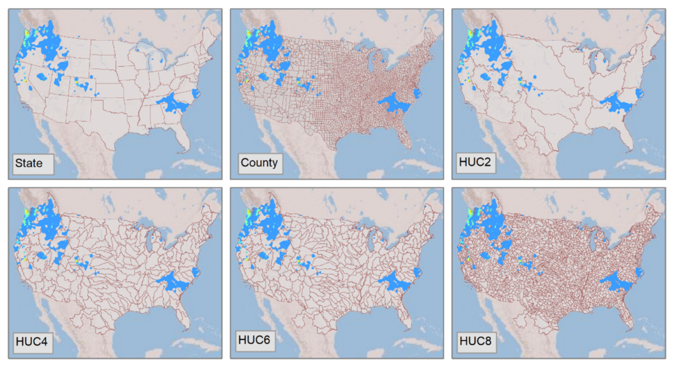
Spatially Averaged Data: Additionally, all variables from the Gridded Data have been spatially aggregated across four levels of HUC basins (HUC2, HUC4, HUC6, and HUC8), states, and counties. The data is available in both .nc and .xlsx formats for downloads. In the .nc files, the spatially averaged data are provided for each model, and in the .xlsx files, the spatially averaged data are provided for spatial units (i.e., state, county, HUC). The 9505V3_SpatialAverage_Download_Links_NetCDF (csv) provides the download links to all the .nc files, the 9505V3_SpatialAverage_Download_Links_byHUC_xlsx (csv) provides the download links to all the .xlsx files for various HUC units and the 9505V3_SpatialAverage_Download_Links_byStateCounty_xlsx (csv) provides the download links to all the .xlsx files for the states/counties.
Data Access Tool: Users may also use the Climate-Hydro Analytics Platform (CHAP) tool to subset to any Hydrologic Unit Code (HUC) basins and retrieve the data in .tiff format. Additional variables and scenarios may be available upon request.
References:
Kao, S.-C., M. Ashfaq, D. Rastogi, S. Gangrade, R. Uría Martínez, A. Fernandez, G. Konapala, N. Voisin, T. Zhou, W. Xu, H. Gao, B. Zhao, and G. Zhao (2022), The Third Assessment of the Effects of Climate Change on Federal Hydropower, ORNL/TM-2021/2278, Oak Ridge National Laboratory, Oak Ridge, TN. DOI: https://doi.org/10.2172/1887712
Rastogi, D., Kao, S. C., & Ashfaq, M. (2022). How may the choice of downscaling techniques and meteorological reference observations affect future hydroclimate projections?. Earth’s Future, 10(8), e2022EF002734. DOI: https://doi.org/10.1029/2022EF002734
Acronyms associated with this dataset:
CMIP6: Coupled Model Intercomparison Project phase 6
CONUS: conterminous United States
DBCCA: Double Bias Correction Constructed Analogues
RegCM: Regional Climate Model
VIC: Variable Infiltration Capacity
PRMS: Precipitation Runoff Modeling System
SSP: Shared Socioeconomic Pathway
GCM: Global Climate Model
SWA: SECURE Water Act
PMA: Power Marketing Administration
USACE: US Army Corps of Engineers
Reclamation: Bureau of Reclamation
HUC: Hydrologic Unit Code
Keywords
Related Records
CMIP6-based Multi-model Streamflow Projections over the Conterminous US, Version 1.1
This dataset presents an ensemble of streamflow projections produced by the SECURE Water Act Section 9505 Assessment for the US Department of Energy (DOE) Water Power Technologies Office (WPTO). Multiple Global Climate Models (GCMs) from the Coupled Models Intercomparison Project phase 6 (CMIP6) are downscaled using either statistical (DBCCA) or dynamical (RegCM) downscaling approaches based on two meteorological reference datasets (Daymet and Livneh).
View DatasetCMIP6-based Multi-model Hydroclimate Projection over the Conterminous US
This dataset presents a suite of high-resolution downscaled hydro-climate projections over the conterminous United States (CONUS) based on a six-member General Climate Model (GCM) ensemble from the state-of-the-art Coupled Models Intercomparison Project phase 6 (CMIP6).
View DatasetCMIP6-based Multi-model Streamflow Projections over the Conterminous US
This dataset presents an ensemble of streamflow projections based on the hydroclimate projections dataset supporting the SECURE Water Act Section 9505 Assessment for the US Department of Energy (DOE) Water Power Technologies Office (WPTO).
View DatasetThe Third Assessment of the Effects of Climate Change on Federal Hydropower
Kao, S.-C., M. Ashfaq, D. Rastogi, S. Gangrade, R. Uría Martínez, A. Fernandez, G. Konapala, N. Voisin, T. Zhou, W. Xu, H. Gao, B. Zhao, and G. Zhao (2022), The Third Assessment of the Effects of Climate Change on Federal Hydropower, ORNL/TM-2021/2278, Oak Ridge National Laboratory, Oak Ridge, TN.
View PublicationHow May the Choice of Downscaling Techniques and Meteorological Reference Observations Affect Future Hydroclimate Projections?
Rastogi, D., S.-C. Kao, and M. Ashfaq (2022), How May the Choice of Downscaling Techniques and Meteorological Reference Observations Affect Future Hydroclimate Projections?, Earth’s Future, 10, e2022EF002734,
View PublicationCMIP6-based Multi-model Hydropower Projection over the Conterminous US, Version 1.1
This dataset presents a suite of hydropower projections for the conterminous United States (CONUS), derived from multiple downscaled and bias-corrected Global Climate Models (GCMs) from the Coupled Model Intercomparison Project Phase 6 (CMIP6).
View Dataset