Hydrosource may experience outages May 15-17 due to scheduled ORNL maintenance.
Skip to content
Hydrosource
Menu Trigger
Home
Data
Datasets
Maps
Tools
Learning
Publications
News
About Us
Contact
Filter
Close filter
Science Themes
Economics (15)
Energy (32)
Environment (3)
Regulatory (5)
Resource Assessment (5)
Water Resource Management (1)
Keywords
Added Capacity (2)
Capacity Update (2)
Development (2)
Development Pipeline (11)
Existing Assets (10)
FERC Exemption (2)
FERC license (2)
FERC Licensing (2)
FERC permit (2)
Fish Species (2)
HMR (2)
Hydropower (1)
Hydropower capacity (1)
Hydropower Construction (2)
Hydropower Generation (27)
Hydropower Permitting Status (2)
Manufacturing Locations (1)
Market Report (10)
National Hydropower Map (7)
New hydro (2)
New Stream-Reach Development (1)
Non-powered Dam (3)
Pipeline (2)
Planned Hydro (2)
Pumped Storage Development (2)
Pumped Storage Hydropower (4)
Relicense (3)
Reservoir Sedimentation (1)
Reservoir Storage Loss (1)
Retired Facilities (1)
Sediment Management (1)
Supply Chain (1)
Unit Addition (2)
Water Injection Dredging (1)
Authors
Antonia Chu (1)
Carly H. Hansen (1)
Debjani Singh (2)
Erik H. Schmidt (9)
Jiyong Lee (1)
John Shelley (1)
Megan M. Johnson (8)
Mimi McHale (1)
Mirko Musa (1)
Rocio Uría-Martínez (7)
Soumendra Bhanja (1)
Thomas A. Ruggles (1)
Organizations
HydroSource (9)
Institutions
EPFL – École Polytechnique Fédérale de Lausanne (1)
Oak Ridge National Laboratory (9)
University of Kansas (1)
US Army Core of Engineers (USACE) (1)
Map Types
Interactive (5)
Static (29)
Apply
Clear All
Home
Data
Maps
Page 4
Maps
Filter
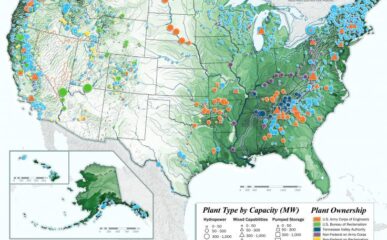
The 2018 National Hydropower Map
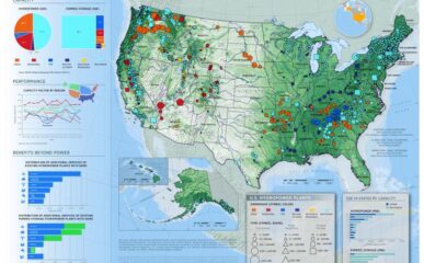
The 2016 National Hydropower Map
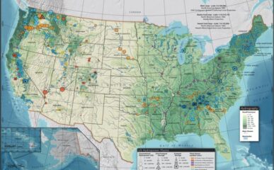
The 2014 National Hydropower Map
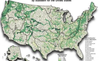
Map of New Stream-reach Development (NSD) Potential by Subbasin for the United States
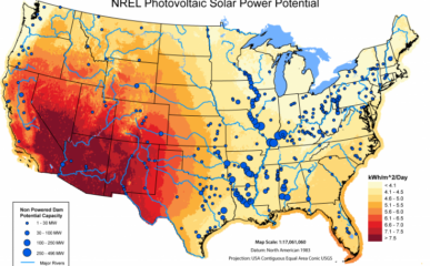
Map comparing non-powered dam and photovoltaic solar power potential
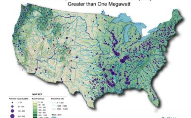
Map of U.S. Non-powered Dams with Potential Capacity Greater than One Megawatt
Map comparing non-powered dam potential to Average Annual Wind Speeds
Total Potadromous or Diadromous Fish Species by Sub-basin in the United States, 2013
<<
1
2
3
4
Cancel
Search