Citation
Carly H. Hansen, Antonia Chu, Jiyong Lee and Mirko Musa. 2026. Reservoir Sediment Management and Monitoring Database. HydroSource. Oak Ridge National Laboratory, Oak Ridge, Tennessee, USA. DOI: 10.21951/res_sed_mgmt/3019328
Overview
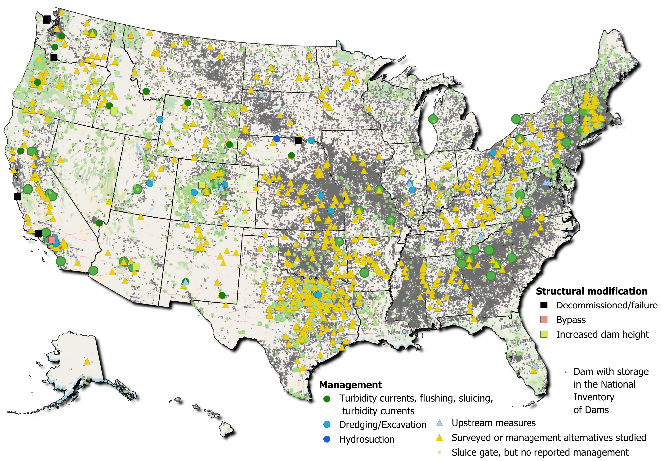
This dataset compiles dam sediment management and monitoring information from surveys, case studies, and journal articles. Additionally, features described by the National Inventory of Dams (i.e., presence of sluice gates) are included to indicate known infrastructure features that may address sediment releases. The location and description of records from downstream monitoring gages are catalogued in order to help with tracking conditions over time (e.g., before and after management actions, as operations change, etc.). The data help address national scale understanding of challenges and solutions related to the accumulation of sediment behind a dam as well as downstream passage. Sediment trapping causes problems as it reduces storage capacity, disrupts dam and reservoir function, impedes access for recreation, alters water quality/habitat conditions, and contributes to riverbank and coastal erosion within the reservoir. Data compilation from a variety of sources is a first step towards assessing system-wide efficacy of management solutions.
This dataset was developed under the Water Power Technologies Office funded effort which began as a Seedling on Reservoir Sedimentation Data, and was supported by the Reservoir Sedimentation Modeling Framework and Data Analysis project. These projects have addressed challenges in describing sediment transport, trapping, and management at dams throughout the US.
Methodology
An outer join on dams/reservoirs with surveys and survey reports (documented in the RESSED database, USBR or USACE databases, project websites, etc.) with the National Inventory of Dams, based on the NIDID to determine dams with documented management and/or sluice gates. Additional dams with documented management activity were identified through review of technical articles from the past 25 years in Journal of Hydrology, Journal of Water Resources Planning and Management, Geomorphology, Journal of Hydraulic Engineering, Water, Journal of Cleaner Production, International Journal of Sediment Research, Nature Scientific Reports, Earth Surface Processes and Landforms, and Environmental Science and Pollution Research. Individual records were created for each survey or management activity documented.
To evaluate downstream sediment monitoring records, the nhdPlusTools and dataRetrieval packages in R were used to find gages within 10km of each dam in the management database. Length of record and location of matched gages were retrieved for those parameters relevant to sediment concentration or total sediment discharge.
References
USBR. 2025. Technical Service Center. Reservoir Surveys. Available at https://www.usbr.gov/tsc/techreferences/reservoir.html
Texas Water Development Board. 2025. Surface Water. Lake Surveys. Available at https://www.twdb.texas.gov/surfacewater/surveys/completed/list/index.asp
USACE. 2024. Enhancing Reservoir Sedimentation Information Web Portal (RSI). Retrieved September 5, 2024. Restricted access.
USACE. 2025. National Inventory of Dams. Retrieved August 18, 2025. Available at https://nid.usace.army.mil/#/downloads
USGS. 2026. National Water Information System data available on the World Wide Web (Water Data for the Nation), accessed January 28, 2026, at http://waterdata.usgs.gov/nwis/.
Science Themes
Related Records
Reservoir Storage Capacity Change (ResCap)
This dataset contains reservoir storage capacities based on conducted surveys in CONUS.
View Dataset